Friday, October 29, 2010

Looking at the sky


I live in an insulated world. Air conditioning. Closed windows. I walk into my garage, open the door and drive my air conditioned car to work. I walk about fifty feet from the covered parking to the door of the office. My life is a series of moving from one air conditioned environment to another. 

Every so often, I go outside. Hmmm. What is that bright light in the sky. Some one should do something about the temperature, it is really hot. I wouldn't mind it if they would turn down the blowing air. What are those white blobs in the sky? I don't remember seeing them before. I heard someone talking about clouds. Maybe those are clouds? I guess its time to go back inside, I've had enough fresh air and clouds and sky and sun and stars for a while. I wonder why I feel like a worm?


Thursday, October 28, 2010

Bryce Canyon


It is time to venture outside of Arizona. Remember, the Colorado Plateau includes parts of Arizona, New Mexico, Colorado and Utah. In walking around Arizona, I do wander over the border into foreign territory once and while. Bryce Canyon is a fabulous place to visit. It is highly accessible, in most places you can drive right up to the overlooks and walk less than 100 feet from your car. On the other hand, it is also mysterious and inaccessible. The trailheads for almost all of the trails, start at the rim and go down, so it is a canyon experience. You have to walk back up after hiking. On the average day it is entirely overrun with tourists from all over the world with a lot of Japanese and Europeans. I am certain that a lot of the time there are more foreign tourists than there are U.S. citizens. 

There is almost no where in Bryce that you cannot find something to photograph. 

Monday, October 25, 2010

Where the skies are not cloudy all day?


When I came back to the U.S. after two years in Panama, I almost turned around and went back when I saw how smoky and yucky the air quality was on the East Coast. The only thing that kept me going was the thought that when I got out West, I could see blue skies and clean air again. Hmmm. Good thing that was many years ago. Today, the air quality in the lovely skies of Arizona is not that great. If I had arrived with today's skies, I might be writing in Spanish from Panama. This shot is across the Grand Canyon from the North Rim looking south towards the San Francisco Peaks. Like the air quality? I don't. The last time I went to the North Rim the air was even worse and I took almost no pictures of the Canyon. What use is it having a world class scenic attraction if you can't see it?

Sunday, October 24, 2010

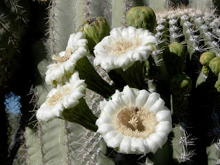
Saguaro Blooms


The saguaro cactus has become synonymous with the desert Southwest. The standard cartoon saguaro has two arms and a few random spines. There is even a website to teach you how to draw a saguaro cactus complete with the obligatory two arms. Even though they may appear as simple objects when stylized, they are very complex organisms. In addition, their growing range is rather restricted to a relatively small geographic area almost exclusively in southern and central Arizona. John Ford movies to the contrary, there aren't any saguaro cactus in Monument Valley or anywhere above about 3000 feet.

The saguaro blooms in late June or early July and the major pollinators are bats. They are protected in Arizona by laws imposing heavy fines for removing one from the desert. But they are not rare, we have two of them growing in our front yard.

Friday, October 22, 2010

Big Lake-- best for Arizona fishermen


On the eastern edge of the state, up on the Colorado Plateau, there is a range of rounded mountains referred to as the White Mountains. Because the Plateau is already at about 6000 feet, the mountains do not appear very high, but the peaks are over 10,000 feet and Mount Baldy which is considered to be the second highest mountain in Arizona, however it is really about the seventh since several of the named peaks around the Kachina Wilderness in the San Francisco Peaks are higher.

The White Mountains give the impression of a gently rolling landscape alternating between dense pine and fir forests and open grasslands. Dotting the area are several lakes, some of reasonably large size. Almost all of these "lakes" are really catchment basins or reservoirs. Big Lake is the largest and best known of the lakes. It is located in the Apache-Sitgreaves National Forest about 30 miles south of Springerville/Eager. It is also about an hour's drive from Pinetop/Lakeside. Big Lake is situated at an altitude of over 9000 feet and so the summers are short and cool and the winters are long and very cold. The lake freezes over, usually by November.

If you like to fish, of which I am not overly fond, it is one of the best trout fishing lakes in Arizona. It is one of the nicest places to camp in the state with very nice campgrounds by Arizona standards that include showers and running water. Both of these amenities are at a premium in Arizona campgrounds in general. 

The above photo shows a small portion of the lake but illustrates the nature of the surrounding country.

Thursday, October 21, 2010

The highest point in Arizona -- Humphreys Peak


The view from Humphrey's Peak looking towards the north and the Grand Canyon. Of course, you can't see the canyon because it goes down and nothing sticks up. In addition, the air quality in northern Arizona is not what it used to be. Smoke from the large coal burning power plants create a haze that obscures most of the distant mountains and cliffs. The climb to the top of Humphrey's follows a zig-zag steep trail that is very rocky near the top of the ridge. I always consider "the wall" to be about 11,000 feet, that is where I usually begin to feel the effects of the altitude. There does not seem to be a consensus on the actual elevation of the highest point but it is approximately 12,666 feet according to a the sign at the top. However, other sources put the elevation somewhat lower at 12,637 feet.

Humphrey's Peak is one of several high peaks that surround a huge volcanic caldera. The peaks form a ridge semi-circling the caldera. The trail reaches the ridge well below the summit and the trail follows the  ridge line for a mile or so. As you climb along the ridge, you see several false summits before you finally walk far enough to see the final switchbacks up to the real one. 

Going down is definitely easier than climbing. The trail is supposed to be 4.7 miles, but you usually have to hike about two miles to the gate where the trail actually begins, so the round trip is closer to 12 miles than 9. Some claim that this is the "best hike in Arizona." I wouldn't dispute that it is one of the best, but I would place several other hikes above this, including the North Kaibab Trail and the Bright Angel Trail.

Wednesday, October 20, 2010

Yes, there is a Fall, Virginia...


Yes, there is a Fall and a winter also, just not so much in the low desert. I remember distinctly having leaves fall off the pecan trees about Christmas time. In Arizona, the leaves turn when it gets cold, just like it does every place else, but in some years it never gets cold and  I guess they have to get together and vote on when to turn some sort of color and fall off the trees. Usually, the trees are budding out or flowering before the last of the leaves have fallen.

Things change dramatically as you drive into higher elevations, on the North Rim of the Grand Canyon at over 9000 feet, the leave were not only turned by mid-October, but some trees were already bare. In less than a day, actually in a matter of a few hours, you can drive from late Fall back into summer heat of over 100 degrees. This dramatic contrast is what makes Arizona (and Utah and most of the other Western States) such an interesting place to live and visit.

Ok, now I have an admission to make. The above photo was not taken in Arizona. It is really in Utah. I have seen colors like that in Arizona, but mostly the leaves on the Rim or further north are yellow Aspen trees.

Tuesday, October 19, 2010

Agatha Peak


Just south of the northern border of Arizona with Utah, near Monument Valley, is Agatha Peak (also known as El Capitan), the core of an ancient volcano. It is said by the Navajos that she is a story teller mother with her children sitting around her feet in rapt attention. Arizona has several of these volcanic cores, one famous one is Weaver's Needle.

Sunday, October 17, 2010

When it rains, it can really rain


The storms of the past week or so in Arizona reminded me of storms in past years. I found these older photos of a day in August of 2005 showing the normally very dry street.


Most of the time, the water doesn't have anywhere to go, so the cities require the builders to make "retention basins" usually about five acres of open land that is dug down to allow drainage. Some of these basins are used as parks and when it really rains, they become small lakes.


As always happens in the Salt River Valley, whenever there is a big rainstorm, all of the young people come out to play in the rain and dance in the streets. 

Saturday, October 16, 2010

Out of the storm

A sudden downpour at the edge of House Rock Valley fills the washes. 


The rain is not enough to cause a flood, but in this desert any water is noteworthy.


Coming down off of the hill, we soon outpace the thunder storm.


Desert storms can be impressive but not long lasting.


Friday, October 15, 2010

Desert wildfire


A prolonged drought in Arizona caused a huge fire danger. This fire never made the headlines but it burned a significant amount of Sonoran Desert vegetation. Here are a few more shots of the fire:


Thursday, October 14, 2010

Cinder Knoll


Some of the most dramatic skies and vistas in Arizona are visible on the Colorado Plateau, just north of the White Mountains. This area is called the Springerville Volcanic Field. As you can see, there are virtually no trees. The ground is either lava rock or cinders. Before they built two coal fired power plants in the area, you could see for 40 or 50 miles. On one hill, we figured out once, that we could see almost 10% of the state of Arizona.

Unlike Sunset Crater near Flagstaff, Arizona, these hills are not mounds of unconsolidated cinders. They are partially lava flows with mostly consolidated cinders. There are over 400 different volcanic vents in this area and it is the third largest field in the continental United States.

Wednesday, October 13, 2010

The end of time


When I first started taking photographs many, many years ago, I was fascinated with sunsets and I still am. I love the progression of colors as the sun approaches the horizon and then disappears. As I have said many times before, bad weather makes good photographs. Unfortunately, good sunsets do not necessarily make good photographs. Usually, the scale of the color changes in the sky require a really wide angle lens. If you try to take a panoramic photo without an exceptionally wide angle lens, the light can change significantly by the time you take enough exposures to make a good panorama. Also, the color you get from either negative film or with the newer digital cameras is never quite like the original sunset.

The standard sunset picture is a staple in almost any travel or landscape related publication. Most of my early attempts at sunset photography were a disaster. Since I did not take the photos with a tripod, they frequently were blurred and useless. The above picture is more recent. It was taken on the road from Fredonia, Arizona to Hurricane, Utah. Because of the heavy cloud cover, I was able to take a picture directly into the sun. Even so, the color in person was much more dramatic than that shown by the photo and you may have a number of other criticisms of the picture. 

 I took a series of sunset pictures just a short time ago and deleted almost all of them from my files. It is not easy to get a good picture.

Cactus at the Botanical Gardens -- up close and personal


I am always amazed at the variety of forms of cactus and succulents. Few places in the world offer the opportunity to see so many different desert plants than the Desert Botanical Gardens. Located off of McDowell Road next to Papago Park, between Phoenix and Scottsdale, the DBG is a wonderland of shapes and forms.

Although there is not yet a complete catalog of every cactus species, some remain to be discovered, there are presently more than 2000 different species. Within the species there are huge variations.


Technically, this agave is not a cactus, but is a succulent.


Tuesday, October 12, 2010

The Gilbert Riparian Preserve at Water Ranch


Fall and Spring are the times to visit the Gilbert Riparian Preserve at Water Ranch. Located on 110 acres right in the city of Gilbert, Arizona at the corner of Guadalupe and Greenfield Roads, the Riparian Institute hosts a variety of activities from a dinosaur dig to telescope observatory. There are several large lakes that host a huge assortment of migratory birds and some permanent residents.


The Preserve is right next to the Southeast Regional Library of the Maricopa County Library System and convenient to many local businesses as well as a huge suburban population.  The photo above shows a Desert Broom in full bloom with the seeds spreading like snow (whatever that is). If you live somewhere else, you can get the same effect from cattails.

Looks like it is time for me to visit the Preserve with my tripod and long lens. Stay tuned for more pictures.

Posted by Picasa

Monday, October 11, 2010

A sense of balance


Have you ever tried to balance a card or a some other object? Do you realize how hard it is to balance an irregular object, like a rock on a small base? The hillsides below the Vermilion Cliffs is a wonderland of balanced rocks. Here are only three examples. I am sure that there are very detailed scientific theories for how these rocks are formed, but I am also sure that I don't fully believe the theories. There is always a component of unreality in balanced rocks.


As you can probably guess, this part of northern Arizona is not seismically active. Part of the wonder is not that these rocks exist, but that there are relatively few of them compared to all of the rocks on the hillside. All of these lovely formations are located along the road leading from U.S. Highway 87A to Lee's Ferry


Sunday, October 10, 2010

Lee's Backbone


There are few places in the Southwest with more drama and less fame than Lee's Ferry. From a previous post, here is a quote from LDS Church President Wilford Woodruff:
"The worst hill Ridge or Mountain that I Ever attempted to Cross with a team and waggon on Earth. We had 4 Horses on a waggon of 1,500 lb. weight and for two rods we Could ownly gain from 4 inches to 24 with all the power of the horses & two men rolling at the hind wheels and going Down on the other side was still more Steep rocky and sandy which would make it much worse than going up on the North side. The trip down the backbone and across the river tested one's resolve to continue the trip. As one weary traveler observed, If Mr. Lee had a backbone as bad as that I surely pity him. It didn't seem possible for the horses to pull the wagons up as the road was so sleep and the boulders so big, and it was just as bad on the dugway on the other side. Everyone who ever came over that piece of road had great cause for thankfulness they were not killed."
From the perspective of the above photo, the ridge seems to rise at a manageable angle. But is it hard to imagine that there was ever a way for vehicles to drive up the rugged, rocky top of the ridge.  When I visited Lee's Ferry in past years, I could never really figure out where the actual crossing was or where the pioneers went when the crossed the river. Finally, I spent the time to read the history and research the locations. The crossing is about a mile up the river from the boat dock and had I spent the time to walk, I would have found a number of National Park Service signs telling me about the various locations. 

The first time we went to the actual crossing site, it was about 110 degrees and it seemed like a very long hike. The second time the temperature was in the 70s and it was much more pleasant. However, there were millions of mosquitoes and other bugs. I don't know which was worse, the mosquitoes or the heat. 

It is a very difficult place to get good pictures due to the extreme contrast between the sun and shadows. There is no neutral setting for the camera that will show both. The picture above is taken from part way along to the river towards the ferry site, looking southwest.

Saturday, October 9, 2010

Lee's Ferry - Gateway to Arizona


Lee's Ferry has a long and storied history. For many years it was the one of the very few ways to cross the Colorado River Canyon system dividing Utah from Arizona. The ferry boat location was just about where I was standing to take the above picture. The ferry crossed the river just to the left of the picture. Traces of the old wagon road are clearly visible on the opposite side of the river, leading towards the slanted sandstone ridge, barely visible, in the middle of the picture, called Lee's Backbone. The water tower in the distance supplies some government offices, the boat launching platform area and Lonely Dell, the historic residence of the ferrymen and women. 

Lee's Ferry is presently more popularly known for three things, tours up the canyon, river raft trips down the canyon through the Grand Canyon and trout fishing. Just below the boat launch ramp, there is a small rapid, the first that boaters down the canyon confront on their whitewater rafting trips. Oh, and Lee's Ferry is the end of the trail for hikers all the way through the Pariah Canyon from White House in Utah, some 48 miles away by foot. 

We find it a convenient stopping place to camp on our way driving to Utah. It is pretty pricey for a campground when you also have to pay the entry fee into the Recreation Area, but with a Golden Age Passport, entry is free and the campground is half price. If you don't mind bugs and snakes it is a pretty nice place to camp. 

Friday, October 8, 2010

Flip Waterfall in the Superstition Mountains

One spring, a long time ago, I took a short hike into the Superstition Mountains. Unusually, there had just been some rain and many of the washes were running with water thereby creating waterfalls. This strange little waterfall probably only runs once or twice a year for a day or two. It follows a curved path down the rock until it hits the lip and then it flips sideways and spurts out into the pool at the bottom. I doubt I could ever find the same place again, but sometimes when it rains, I wonder if I could?

Thursday, October 7, 2010

The beauty of the Vermillion Cliffs


This panoramic shot was taken in the early morning. The unusual color of the cliffs, even more intense than usual came about as a result of a forest fire on the Kaibab Plateau. The sun came up dark and red, barely showing through the smoke. The effect on the light was dramatic, giving the whole scene an unearthly quality. The picture is quite accurate as to how the cliffs looked from Lee's Ferry. The cliffs are a 3000 foot escarpment and are now a National Monument

Rock Fall on Lake Powell


In 1969 Lake Powell was filling rapidly after the final construction of Glen Canyon Dam. We took a trip from Bull Frog Basin to the Escalante Canyon in canoes. One of the most remarkable things that occurred was a huge rock fall from the canyon wall. The first picture is just before the rock peeled away from the cliff. We noticed the rock because it looked like it was smoking. Small rocks were falling down behind the big slab as it moved slowly away from the cliff.


We guessed what was happening and began to slowly drift away from the rock on down the lake. While we watched the rock fell off the cliff into the lake. Had the lake been more shallow, we would have been washed away, but because of the depth, the wave did not break and we were able to escape harm.


Our friends had gone on down the lake and were about a mile away. To them it looked like the whole cliff came off and then we disappeared in the spray. They thought we were washed away. So did we. The spray went 3/4 of the way across the canyon, which was close to a mile wide at this point. It is hard to get  the perspective of the size of the fall from these small pictures, taken with a half frame film camera that had to be advanced between each shot. When the rock fell, I took this picture, stuffed the camera in a plastic bag, yelled to get out of there and put the bag in my teeth and started paddling like crazy.


Here is the spot on the cliff where the rock was standing. No one would ever guess that a rock had fallen into the lake. 

Wednesday, October 6, 2010

Optical Illusion or upside down?


At first glance, it is hard to determine whether this photo is upside down or not. Guess what? When you are standing there, you can see the same thing. It is often hard to resolve the rocks and water and sky into their individual components. One time while kayaking on a lake, the reflections were so real, we felt disoriented, like we were floating through the air. At this point, Marble Canyon, in the picture above, is about 800 feet wide and 400 feet deep. By the time Marble Canyon merges with the Grand Canyon, it is 4,000 feet deep and two miles wide. Click here, for a USGS Map showing Quaternary Geology and Geomorphology of the Lee's Ferry Area, Glen Canyon, Arizona

Tuesday, October 5, 2010

Sky, Water and Sandstone - a magic mixture


There are plenty of places on the beautiful Colorado Plateau where you can see sandstone and the sky is always a huge presence, but there are few places where the three mix, but when they do, the mixture is magic. This early morning photo of the Colorado River at the old Lee's Ferry site, combines the light and shadow of the Marble Canyon cliffs with the almost mirror still water of the river, reflecting the edge of the storm clouds. Lee's Ferry is a small island of green in a huge ocean of sandstone and clay. As you view the rocks, you can only faintly imagine what the early pioneer settlers thought of the place as they precariously crossed the then untamed river. 

No one can visit a place like Lee's Ferry without being changed. It is not a neutral location. In the background, is the constant roar of the rapids just below the ferry site. You might compare it to the sound of a nearby freeway, but the sound never varies in intensity or volume. The canyon is also one of the few places in Arizona, where the sky can be considered to be truly dark. Surprisingly, it also has high quality cell phone service. 

Monday, October 4, 2010

Patterns, patterns, patterns


Unless you know, it is pretty hard to tell what this picture shows. So you don't keep guessing, it is a sand bar along the bank of the Colorado River in Marble Canyon. Sometimes, you have to step back and take a second, longer look at the world around you to notice the patterns. Some patterns are obvious, like clouds in the sky, but others are more subtle, like the sand bar above. I find it interesting that many people see no patterns at all. To them, all nature is blur, a background to their life they never see and never experience. How long has it been since you sat and watched the sun set? I mean, watched the light and shadows change slowly as the sun sinks below the horizon? Do you really see what is around you? 

As a photographer, I deal in patterns. It is amazing how the real world is translated and changed by the camera and the light recording process.

Sunday, October 3, 2010

Condors in House Rock Valley


The California condor is said to be one of the world's rarest and most imperiled vertebrates. It was first listed as an endangered species in 1967. Quoting from "Land Use History of North America - Colorado Plateau, "The condor is a member of the family Cathartidae, the New World vultures, a family of seven species, including the closely related Andean condor (Vultur gryphus) and the sympatric turkey vulture (Cathartes aura). California condors are among the largest flying birds in the world. Adults weigh approximately 10 kilograms (22 pounds) and have a wing span up to 2.9 meters (9 ½  feet)." 

We drive through the House Rock Valley, below the Vermilion Cliffs quite frequently and for years we have stopped and looked for condors. We often heard reports that they were sighted at the Grand Canyon, or near Navajo Bridge. Finally, we decided to make a major effort to spot the elusive birds. For the past few times we have gone through House Rock Valley, we have stopped at the release point, which is just north of Highway 87A. We heard from the people at the tourist store at Navajo Bridge that the condors sometimes roost near the bridge. 


With this in mind, our trip to northern Arizona included a goal to find the condors. We spent three days looking without results and then on the last day of our trip, on the way back down to the desert, we stopped off at Navajo Bridge. At first we could not see any signs of the birds. But then I saw what I thought was a condor land on a rock some distance from the bridges. There are two bridges at Navajo Bridge, the old one is now a walkway. The newer one is for traffic. Shortly, the first bird was joined by three more. They flew back and forth under the bridges and perched on the rocks of the cliffs. It was spectacular. 


More later on the condors.

Saturday, October 2, 2010

Tent Caterpillars


Tent caterpillars are moderately sized species in the genus Malacosoma and in the moth family Lasiocampidae. See Wikipedia. The picture above was taken far out in the desert on the Colorado Plateau. When I was young, I was fascinated by the web tents in trees and bushes. Tent caterpillars were just uncommon enough to evoke a little bit of uncertainty. I wasn't quite sure if they were dangerous or not. One of the rumors that circulated among children at the time was that certain caterpillars were poisonous, especially their spines. The braver of the boys (and some girls) would pick them up and let them walk up their arms or sleeves. The more timid would run away if the braver children tried to put a caterpillar on their arm or hand.