Saturday, October 31, 2020

Limes


I lived in the Salt River Valley for most of my life. We were surrounded by citrus trees everywhere I lived once we moved to the edge of the city. We had oranges, grapefruit, lemons, tangerines, and sometimes limes. Unfortunately, the lime trees were overly sensitive to frost and would freeze every few years. Now that we live in Utah, we have to buy citrus in a store but we can't justify paying the prices they charge since we spent so many years basically getting all our citrus for the cost of watering and caring for the trees. 

Friday, October 30, 2020

Deer Creek Reservoir, Utah


Except for the higher mountains, most of Utah is very dry and technically a desert. Here is the current definition of a desert from the USGS article "What is a desert?"

There are almost as many definitions of deserts and classification systems as there are deserts in the world. Most classifications rely on some combination of the number of days of rainfall, the total amount of annual rainfall, temperature, humidity, or other factors. In 1953, Peveril Meigs divided desert regions on Earth into three categories according to the amount of precipitation they received. In this now widely accepted system, extremely arid lands have at least 12 consecutive months without rainfall, arid lands have less than 250 millimeters of annual rainfall, and semiarid lands have a mean annual precipitation of between 250 and 500 millimeters. Arid and extremely arid land are deserts, and semiarid grasslands generally are referred to as steppes.

In case you don't automatically convert metric measurements, here are the equivalents: 250 millimeters = about 10 inches and, of course, 500 mm is about 20 inches. Heber Valley where the Deer Creek Reservoir is located gets about 20 inches of rain a year making it right on the edge of the semi-arid definition. Where I live in Provo, we get about 18 inches of rain a year. The U.S. average rainfall across the entire country is about 38 inches of rain a year. However, currently, Utah County, where we live and the location of the Deer Creek Reservoir are both under an Exceptional Drought. The entire state has had less than an inch of rain in the last 60 days. 

Thursday, October 29, 2020

Arlington National Cemetery, Virginia


A trip to Washington D.C. would not be complete without a visit to the Arlington National Cemetery. Here is a short description from the official website

The Office of Army Cemeteries (OAC), consisting of Arlington National Cemetery in Arlington, Virginia and Soldiers’ and Airmen’s Home National Cemetery in Washington, D.C., is under the jurisdiction of the Department of the Army. The secretary of the Army consolidated authorities and created the executive director position to effectively and efficiently develop, operate, manage and administer the program.

Arlington National Cemetery conducts between 27 and 30 funeral services each weekday and between six and eight services on Saturday. The grounds honor those who have served our nation and provide a sense of beauty and peace for our guests. Rolling green hills are dotted with trees that are hundreds of years in age, complementing the gardens found throughout the cemetery's 639 acres. This impressive landscape serves as a tribute to the service and sacrifice of every individual laid to rest within these hallowed grounds.

I have been to the cemetery several times but on this trip, I took the opportunity to walk through most of the cemetery in the beautiful Fall weather. 

Wednesday, October 28, 2020

Heber Valley Railroad, Heber City, Utah


The Heber Valley Railroad runs from Heber City, Utah to Vivian Park in the Provo Canyon. Here is a description of the railroad from Wikipedia: Heber Valley Railroad.

The Heber Valley Railroad (HVRX) is a heritage railroad based in Heber City, Utah. It operates passenger excursion trains along a line between Heber City and Vivian Park, which is located in Provo Canyon. The HVRX carries over 110,000 passengers a year.

The railroad line is approximately 16 miles (26 km) long. A typical round trip ride on the train takes about 3 hours. There are a total of four passing sidings outside of the Heber yard limit. Notable landmarks seen from the train include Mount Timpanogos, Cascade Mountain, Deer Creek Dam and Reservoir, Provo River, Sundance Ski Resort, Tate Barn, and Soldier Hollow. A variety of wildlife including deer, eagles, fox, moose, turkeys, hawks, mountain lions (cougars), and beavers, have all been seen from the train as well.

We spent a very pleasant day trip driving to Heber City and taking a ride on the Railroad. It was a beautiful trip. 

Monday, October 26, 2020

Heber Valley Railroad Engine 300, Utah


This is Engine 300, a rare 0-6-0 type steam locomotive, now owned by the Heber Valley Railroad located in Heber City, Utah. Here is some background about this rare steam locomotive from SteamLocomotive.info.

No.300 spent all its working life as a switcher at the Columbia Steel Corporation's iron smelting plant at Ironton, Utah. The Ironton Works, as it was known, was one of the largest pig iron plants in the west, and was built beginning in 1922 by Columbia Steel on a 385-acre site near Springville. To move slag cars between the coking plant and blast furnaces, Columbia ordered a single 0-6-0 from Baldwin that was delivered in 1923 and numbered 200. By the next year the plant was in full production, and the first pig iron was produced. Coal (to be converted to coke for use in the by-product ovens) was mined locally and delivered to the plant by Columbia's own short line, the Carbon County Railway.

Columbia returned to Baldwin shortly after the plant opened for an additional 0-6-0, No.300, which was built and delivered in May 1925. Modern in design, the 300 features piston valves, power reverse and a Westinghouse cross-compound air compressor. By comparison, sister 200 was a bit older in design, having just one single-stage compressor. A slope-back tender was necessary for visibility while switching.

Saturday, October 24, 2020

Mount Timpanogos from Deer Creek Reservoir, Utah


I have a number of photos of Mount Timpanogos from the western side facing Utah Valley but this time I am at Deer Creek Reservoir in the Heber Valley and looking at the eastern side of the mountain. It was a beautiful clear day especially after all the days of smoke from the fires this summer. You can see the effects of a very long drought here in Utah and throughout the Southwest from the drop in the water level. 

Friday, October 23, 2020

Fall in Heber Valley, Utah


This was the last day of warm Fall weather. A cold front was moving into Utah with wind and much colder temperatures. The Fall leaves were not at their most colorful but there were still some very striking trees. This is the Provo River Delta as it enters Deer Creek Reservoir. We had a beautiful day in a high mountain valley just a short distance from our home. 

Wednesday, October 21, 2020

Mushrooms in the Front Yard


We seem to have a number of different kinds of mushrooms growing around our house from time to time but this was very unusual. I have never seen such a solid mass of mushrooms before. The weather has been cool and very dry but this part of the yard gets water from a sprinkler. 

Monday, October 19, 2020

Wild Turkeys in Your Front Yard


Although technically we live in a city, we live right next to the Uinta-Wasatch-Cache National Forest. Although the actual forest boundary is about a half-a-mile away, the land between our home and the forest is owned mostly by Provo City and is undeveloped. We have a herd of deer living in our front yard because the heavily forested hill is about ten feet from the side of our house. We see and hear cougars, weasels, bighorn sheep, rats, squirrels, a variety of birds including flocks of quail, and many other animals. This is the first time we have seen a flock of turkeys in our neighborhood.  This is not our yard, but it could be. 

Sunday, October 18, 2020

Provo Canyon Range Fire on Mount Timpanogos, Utah


 I have taken a lot of photos of Mount Timpanogos from my front yard but this is the first major fire photo. The fire is called the "Range" fire because it started in a rifle range in Provo Canyon. Utah is mostly classified as in an extreme drought with significant parts of the state in an exceptional drought. There are two major fires burning at the time this photo was taken. For a while, we thought the fire might be coming our direction but it has stayed in the canyon and on the mountain. Here is a screenshot of the Drought Monitor. 

https://droughtmonitor.unl.edu/CurrentMap/StateDroughtMonitor.aspx?UT


Saturday, October 17, 2020

Shoreline of Utah Lake


 Both Utah Lake and the Great Salt Lake in Utah are remnants of the huge Lake Bonneville the largest Late Pleistocene paleolake in the Great Basin of western North America. Quoting from Wikipedia: Lake Bonneville,

The Western Interior Seaway preceded Lake Bonneville. Lake Bonneville was a pluvial lake that formed in response to an increase in precipitation and a decrease in evaporation as a result of cooler temperatures. Lake Bonneville covered much of what is now western Utah and at its highest level extended into present-day Idaho and Nevada. Many other hydrographically closed basins in the Great Basin contained expanded lakes during the Late Pleistocene, including Lake Lahontan in northwestern Nevada.

Here in Utah Valley, we live right next to the "Bench" which is really the old shoreline of Lake Bonneville. Here is some further explanation about this huge lake from the article cited above:

Lake Bonneville was not a “proglacial” lake, although it did form between about 30,000 and 13,000 years ago when glaciers at many places on Earth were expanded relative to today during the last major glaciation. For most of its existence (that is, during the transgressive plus regressive phases) Lake Bonneville had no river outlet and occupied a hydrographically closed basin. Changes in lake level were the result of changes in water balance caused by climate change (a simplified version of the water-balance equation is inputs equal outputs plus-or-minus storage changes). Storage changes are equal to volume changes, and changes in volume are correlated with changes in lake level. When inputs (i.e., precipitation; runoff in rivers) were greater than outputs (i.e., evaporation from the lake surface; evapotranspiration in the basin), lake level rose, and when outputs were greater than inputs, lake level fell. Changes in global atmospheric circulation led to changes in the water budget of Lake Bonneville and other lakes in the Great Basin of western North America. Mountain glaciers in the Bonneville drainage basin stored less than 5% of the water that Lake Bonneville held at its maximum, so that even if all the mountain glaciers in the basin melted at once and the water flowed into the lake (this didn't happen—it took thousands of years for the mountain glaciers to melt, and Lake Bonneville was falling by that time), it would have had little effect on lake level. Lake Bonneville had no river connection with the huge North American ice sheets. While Lake Bonneville existed the patterns of wave- and current-forming winds were not significantly affected by the Laurentide and Cordilleran ice sheets in northern North America.

Friday, October 16, 2020

Fall on the Provo River Parkway Trail


Fall is a beautiful time along the Provo River Parkway Trail. There are mature to very old trees all along the river and the leaves are spectacular. There are a few footbridges over the river in addition to the many streets that also cross the river. The trail goes under the major streets but the footbridges (bicycles also) are picturesque. 

Wednesday, October 14, 2020

Red Bell Peppers


These are one of my staple foods. We mostly eat them on salads but from time to time we have stuffed Bell Peppers. Here is our family's recipe website: Family Heritage Recipes. You can search for recipes that include Bell Peppers. 

Tuesday, October 13, 2020

Detail from the Joseph Smith Memorial Building in Salt Lake City, Utah


 This is a detail from the Joseph Smith Memorial Building in Salt Lake City, Utah. This building is located on South Temple Street right across the plaza to the east of the Salt Lake Temple of The Church of Jesus Christ of Latter-day Saints. The Joseph Smith Memorial Building was previously used as a hotel called the Hotel Utah but today it is a reception center and office building for the Church with two very good restaurants. Unfortunately, the building is closed except for employees during the pandemic. 

Monday, October 12, 2020

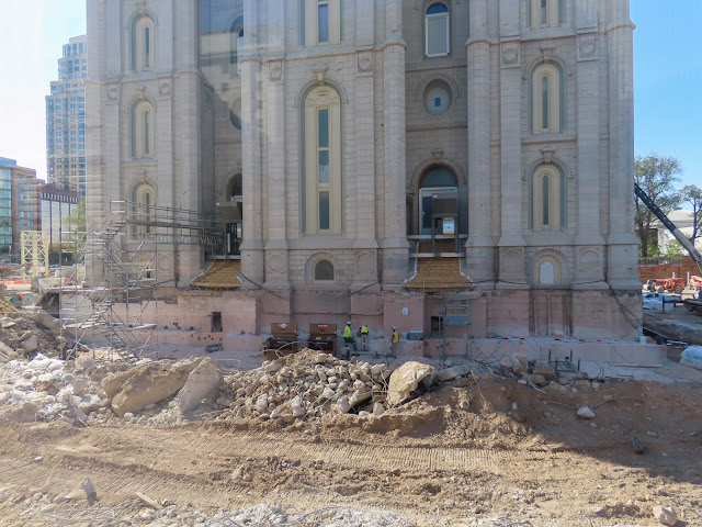
Photos of the Salt Lake City, Utah Temple Renovation


This is a series of photos taken on October 9, 2020, of the renovation of the Salt Lake City, Utah Temple of The Church of Jesus Christ of Latter-day Saints. This first photo shows the complete demolition of the buildings on the north side of the temple including the former annex building. You can't see the buildings because they are gone. If you look at the left side of the photo you can see one of the doors to the temple with the staircase. It is about ten feet or so above the ground showing how much of the fill has been excavated and showing the foundation of the temple.


This photo shows the scaffolding around the spires of the temple. 

This is the east side showing the doors and the excavation now showing the foundation of the temple more clearly. 


This photo shows the southeast corner of the temple and shows more of the excavation and removal of the landscape and the Visitors Center building on the south of the temple lot. 

Moving around to the southwest side of the temple you can see more of the lot with the landscaping and building structures removed. 


This is more of the southwest side of the temple. 

For more information about the reconstruction and renovation see, "First six months of Salt Lake Temple renovation reveal the project’s enormity."

Sunday, October 11, 2020

Looking Over into Tooele Valley


At 9,015 feet above sea level, this may be the highest road in the mountains around the Salt Lake Valley and Utah Valley. This photo was taken from the Bingham Mine Overlook or the Bingham Canyon Overlook depending on what you read. It is one of the few places you can drive to that gives you a view of the Tooele Valley just west of the Salt Lake Valley. 

Saturday, October 10, 2020

Bingham Canyon Copper Mine, Utah


This is the Bingham Canyon Copper Mine in the Oquirrh Mountains on the west side of the Salt Lake Valley, Utah. It is impossible to even begin to comprehend the size of the mine. If you click on the photo and zoom in, you can see the dots that are huge mine trucks almost twenty feet tall. This photo was taken from the Copper Pit Overlook on a very high ridge looking over the mine. The access road to the overlook is barely passible for a regular car but not impossible for a four-wheel-drive, high clearance vehicle. I drove our Subaru Outback up the road without a problem. Here is a short explanation of the mine from Wikipedia: Bingham Canyon Mine.

The Bingham Canyon Mine, more commonly known as Kennecott Copper Mine among locals, is an open-pit mining operation extracting a large porphyry copper deposit southwest of Salt Lake City, Utah, in the Oquirrh Mountains. The mine is the largest man-made excavation, and deepest open-pit mine in the world, which is considered to have produced more copper than any other mine in history – more than 19 million tons. The mine is owned by Rio Tinto Group, a British-Australian multinational corporation. The copper operations at Bingham Canyon Mine are managed through Kennecott Utah Copper Corporation which operates the mine, a concentrator plant, a smelter, and a refinery. The mine has been in production since 1906, and has resulted in the creation of a pit over 0.75 miles (1,210 m) deep, 2.5 miles (4 km) wide, and covering 1,900 acres (3.0 sq mi; 7.7 km2). It was designated a National Historic Landmark in 1966 under the name Bingham Canyon Open Pit Copper Mine. The mine experienced a massive landslide in April 2013 and a smaller slide in September 2013.

Along the Butterfield Canyon Road


Butterfield Canyon is in the Orquirrh Mountains on the west side of the Salt Lake Valley. It is a relatively unknown canyon because of the narrow winding road with steep grades. Part of the road is still unpaved and quite rough. However, for those with some fortitude, the ride is well worth the 10 mph limitations imposed by the road. If you are at all faint of heart when faced with thousand-foot drop-offs on the side of a narrow road, I would not recommend the drive. The weather was fabulous and the Fall leaves were stunning. 

Friday, October 9, 2020

Early Morning at Utah Lake


 As the seasons change, our walks by Utah Lake bring new views and perspectives. We live in the shadow of some very high mountains so the sun comes up much later than the officially noted sunrise time. We can see the sun on the mountains to the west and then watch the shadow of the eastern mountains move across the valley. Here the early morning light has created a dreamy quality of pastel colors. 

Tuesday, October 6, 2020

Clouds over the Vermillion Cliffs, Arizona


 It is hard to understand the scale of this image. The cliffs in the background, partially obscured by the clouds are the Vermillion Cliffs. Those cliffs are about 2000 feet high. What appears to be a ridge in the center of the image is Marble Canyon. If you were to travel over to the edge of the canyon, you would be looking down about 470 feet to the Colorado River. From where I am standing for this photo if you were to drive over to the highway along the face of the Vermillion Cliffs, it would take almost an hour to get to the cliffs on the left side of the image. 

Sunday, October 4, 2020

The Green River at Split Rock Mountain, Utah


The Green River runs south out of Wyoming into Utah but is backed up by the Flaming Gorge Dam. Below the dam, the river turns east and flows into Colorado. In Colorado, the river runs south and then heads west back into Utah where it goes through Split Mountain and continues southwest to Green River where it turns directly south until it joins the Colorado River in Canyonlands National Park. 

Saturday, October 3, 2020

Split Rock Group Campground on the Green River in Dinosaur National Monument #2


Here is another view of the Split Rock Group Campground on the Green River in Dinosaur National Monument, Utah. It is a spectacular place to camp. We thought we would have a lot more people come with us from our family but some of them didn't make it. Too bad. It was a very nice camp. We had an interesting coyote serenade in the early morning hours. It looks dry and dusty. It is.  

Friday, October 2, 2020

Split Mountain Group Campground on the Green River in Dinosaur National Monument, Utah


 Quoting from the National Park Service website for Dinosaur National Monument:

The Split Mountain Group Campground is located along the banks of the Green River at an elevation of 4800 feet. The highly eroded Split Mountain towers over the campground. The campground is near the famous dinosaur quarry, where you can see 149 million-year-old dinosaur bones still encased in the rock. Right beside the campground is the Split Mountain Boat Ramp where river rafters come off the Green River after trips through Dinosaur National Monument's canyons.

 You can see all about this campground on the Recreation.gov website for "Split Mountain Group Campground." By the way, National Forest and National Park campgrounds do not compare favorably with Utah State Parks. This was a lovely place to camp but the facilities at Utah State Parks are much better. 


Thursday, October 1, 2020

The Green River in Dinosaur National Monument, Utah


The Green River is the main tributary of the Colorado River. Dinosaur National Monument is located in both Utah and Colorado. The Green River enters Utah from the east from Colorado and then runs west until turning south and eventually joining the Colorado River in Canyonlands National Park. This photo shows part of the Split Mountain Campground along the river which is located right at the mouth of the Split Canyon.