Saturday, January 31, 2009

The Desert Encapsulated -- Arizona Sonora Desert Museum

Just outside of Tucson lies the Arizona Sonora Desert Museum, one of the most impressive collections of desert animals, gems and minerals, plants and fossils in the entire world. If you would like an encounter with a humming bird, up close and right in your face or if you would like to see the desert underground, the exhibits are interesting, well maintained and highly relevant.

Our visits to the Museum have been memorable to our whole family. There are enough exhibits to keep all ages enthralled for whatever time you have to visit. As their Website states:
Set in the midst of one of the Sonoran Desert's most beautiful settings, the Arizona-Sonora Desert Museum is pleased to make available various facilities that may be rented for meetings, dinners, banquets, and other special gatherings that fall within its mission.
Tickets to the Museum are consistent with other attractions of the same caliber.

Tuesday, January 27, 2009

I survived driving the Apache Trail

Phoenix is a huge metropolitan area of 475.1 square miles. The City of Phoenix is surrounded by a cloud of smaller satellite cities such as Mesa, Scottsdale, Gilbert, Peoria, Glendale, Chandler and many others. At the eastern edge of the Valley is the town of Apache Junction. Although the town has no identifiable downtown area, the main street is called the Apache Trail. In what would be the center of town, if the town had a center, the Apache Trail turns north into the western edge of the Superstition Mountains. It follows the Salt River and overlooks three large lakes, Canyon Lake, Apache Lake and Roosevelt Lake.

The road stretches about 41 miles and for most of its length, it has been preserved in its unpaved glory. Pictures taken along the road do not convey the absolutely rugged nature of the surrounding desert and the possibly terrifying grades and drop offs that confront the driver. It also doesn't help that you share the road with hundreds of others, some of whom are driving huge trucks pulling gigantic boats. At certain times of the year, the dust can be formidable. At other times, the road can be a morass of mud. It is an adventure at any time.

Despite all of the camps, hikes, climbing trips and boating trips, the Apache Trail is still a wonder, even driven in the middle of the night. It is not for the faint hearted or for those with little or no dirt road driving experience. Although the road can be negotiated in the average passenger car, it is evident from following some drivers that they are completely out of their element. The road has a long and storied history having been built to supply the construction of the Roosevelt Dam. It is no longer the only way to reach the Dam or the Lake, but it is the most interesting.

If you come to the Salt River Valley, you will have missed an important part of what makes Arizona special, if you miss the Apache Trail.

Saturday, January 24, 2009

Arizona urban wildlife

Listening to the militant conservationists, you would get the impression that wild animals in general were on the verge of extinction. That pretty propaganda piece, the BBC Planet Earth, portrays a world where all the cute little cuddly creatures are disappearing. For a lot of species that well may be the case, but no one ever mentions that species have been disappearing for millions of years, many of which were likely cute and cuddly. The media leave strictly alone those species that not only are not on verge of extinction, but have extended their range and numbers because they can take advantage of the urban environment. Most of these animals are definitely not in cute or cuddly category, for example coyotes, cockroaches, scorpions, pigeons, rattlesnakes, gophers, not to mention the old standbys, rats and mice.

Take coyotes for an example, these resilient animals have vastly extended their range. They now inhabit such diverse ares as Nova Scotia and Florida. Coyotes are definitely considered pests. It is undisputed that many (if not nearly all) of the signs you see around advertising for a lost cat or dog, are the result of coyote predation. It is not impossible to catch a coyote, but very, very difficult. We live with coyotes in our neighborhood. On a bike ride we saw two large coyotes standing the middle of a major street. When we approached they both ran, one continued down the same street we were riding on, running along a high wall that parallels the road. The coyote turned and ran up an eight foot wall, just like a cat, then stood at the top of the wall and looked at us, then jumped down into the backyard of a home. Despite intensive eradication efforts involving killing over 400,000 of these animals every year, their populations continue to increase. Hal the Central Park Coyote lived for two days in Central Park before being captured in 2006. It is interesting that the very active wildlife biologists have no idea how many coyotes live in my neighborhood. Sightings are not rare, but most people, I assume, think they are looking at a stray dog.

Another beneficiary of urban sprawl is the common pigeon. It not uncommon for pigeons to be scavenging on the local school campuses, eating a steady diet of the same thing eaten by the area's children. Like the children, the pigeons are obese, only taking to the air when approached within a few feet. There are over 97,000 Web sites for pigeon population control. It is always amusing to me to go into a high rise building here in Phoenix and see the spikes, electrical leads and other anti-pigeon measures, usually with a pigeon sitting on the ledge anyway. Wikipedia deals with pigeons as "Rock Pigeons." You guessed it, no one knows (or cares) how many pigeons there are in Phoenix or anywhere else for that matter.

If you would like an amusing activity apply for a federal grant to study pigeons unless you can tie the study into West Nile Virus or some other disease.

What about the rest of the denizens of our urban world in Arizona? Scorpions, definitely not endangered. Rats and mice, not a common as some places in the U.S. but still not about to disappear any time soon. That leave cockroaches. You have to come to Phoenix or some other warm climate area to really appreciate how many cockroaches there are in the world. Try opening a sewer manhole sometime. The only good thing about scorpions (there might be other good things but I haven't spent much time thinking about the good things about scorpions) is that when you have scorpions they eat the cockroaches.

OK, that leaves rattlesnakes. I really shouldn't have included them in this urban tirade, but they are one of the most recognizable "dangerous" animals in Arizona and elsewhere, but what is surprising is that no one seems to know how many rattlesnakes there are. One study concluded that "The survey teams systematically searched areas that were suspected to be good habitat for the species and recorded basic statistics for each rattlesnake encountered. These efforts resulted in the identification of a relatively small number of Arizona black rattlesnakes. For this reason, it was not possible for scientists to determine specific population numbers for individual park units."

I could have included a lot of other animals that are far from any endangered species list, like mosquitoes. But I assume no one is counting them either.

My point? Ecological hand wringing is sometimes pretty selective.

Tuesday, January 20, 2009

More thoughts on Canyon de Chelly

Canyon de Chelly is a different type of scenic destination. It is spectacularly beautiful, it is high accessible and it is relatively well known, but, for example, it is very seldom mentioned or featured in Arizona Highways magazine. There are probably two reasons for this, first and foremost is that it is private property. Although the Canyon is officially designated as a National Monument, it is also on the Navajo Nation and has permanent residents. The Canyon is composed entirely of Navajo Tribal Trust Land. This is the Navajo people's home, it is not on public land.

This fact leads to the second issue, that entrance to the Canyon is controlled and can be pretty expensive both in money and time. Although it is possible to drive around the perimeter of the Canyon and visit the overlooks without charge, going into the Canyon can take an entire day and can be quite expensive. A drive-in tour to see both branches of the Canyon, Spider Rock and Mummy Cave, can easily take eight hours. Prices vary but a short three hour trip can cost up to $60 or $70 per person with an additional charge of almost $70 an hour for longer trips.

If you can afford the trip, it is certainly worth the time and the money, but even comparing this to the Grand Canyon, a very expensive place, and it is much more expensive for a casual visit.

Another factor in the popularity of the Canyon is the difference in accessibility. Since the Grand Canyon has been a destination for so many years, there are a multitude of tours and ways to get to the Canyon. On the other hand, Canyon de Chelly is tucked away, well off the beaten path in eastern Arizona. The facilities are decided limited and the Grand Canyon-like infrastructure is entirely missing. I love the place. It is spectacular, but it must be enjoyed in its own unique context.

Posted by Picasa

Thoughts on Canyon de Chelly


Up in the northeast corner of Arizona, located in the Navajo Nation, is a most remarkable canyon called Canyon de Chelly (pronounced "shay"). Like many places in Arizona it is a study in contrasts. The entrance to the Canyon is practically in the middle of a good sized town, Chinle, Arizona. When I first visited the Canyon, the town was very small and the Canyon seemed to be quite a distance from the town, but over the years Chinle has grown into a major economic center, with a hospital, a number of schools and many government buildings. There are shopping centers and a lot of other businesses. In the U.S. Census for 2000, Chinle had 5,366 people.

Just to the south and east of the town, the entrance to the Canyon is unremarkable and unless you knew that the Canyon was there, you might drive by without noticing it. Canyon de Chelly is one of the longest continuously inhabited places in North America. From the National Park Service description:
The cultural resources of Canyon de Chelly include distinctive architecture, artifacts, and rock imagery while exhibiting remarkable preservation integrity that provides outstanding opportunities for study and contemplation. Canyon de Chelly also sustains a living community of Navajo people, who are connected to a landscape of great historical and spiritual significance. Canyon de Chelly is unique among National Park service units, as it is comprised entirely of Navajo Tribal Trust Land that remains home to the canyon community. NPS works in partnership with the Navajo Nation to manage park resources and sustain the living Navajo community.
Because the Canyon is home to the Navajo people, travel into the Canyon is tightly controlled. There is only one place that you can descend the Canyon walls and visit the floor unaccompanied by a local guide. The hike down to the White House Ruin from the South Rim Drive is one of those locations. Although the hike is short, it is memorable and worth the drive to the Canyon.

If you have time and the money, you can take a guided tour through the Canyon. Authorized Navajo Guides are required and charge $15 an hour for one vehicle and $5 and hour for each additional vehicle with a 5-vehicle limit. Travel in the Canyon is definitely limited to four-wheel drive and sand equipped vehicles. For a larger fee, you can take a guided tour on one of the large four-wheel drive trucks operated by concessionaires.

More later (Thanks to the NPS for the photo above)

Saturday, January 17, 2009

Fat Man's Pass

Descending by airplane into Sky Harbor Airport in Phoenix at night is fantastic experience. But it is amazing how few of your fellow fliers, jaded by years of flying, will even bother to look out the windows. One of the most prominent landmarks is the huge dark curtain of South Mountain, crowned with it sparkling ring of transmission towers. The towers are so visible, they are a certain reference point to orient any guess at which part of the valley you are flying over. In the daytime they are an almost invisible backdrop to the city.

But spend a few hours and drive to the edge of these urban mountains and you will experience one of the most contradictory wilderness experiences possible, hiking in solitude in an almost untouched desert environment while overlooking one of the largest cities in America. Granted, some of the trails are so overused as to be beaten to powder, but the western end of the enclave is as remote as any mountains could be so close to a large city. The further west you go, the more solitary your hiking experience.

South Mountain Park is one of the largest, at 16,283 acres, if not the largest city park in the United States. At the eastern end of the mountains lies one of the most unusual and surprising destinations of the Park, Fat Man's Pass. This rock canyon is located in Hidden Valley, a valley whose hills block out any view of the City and transform the small environment into a magical place of Indian Petroglyphs and a very small intermittent stream. The most prominent feature of the valley is a ridge of rocks on the west side, with a narrow crack of an entrance or exit giving the area its name.

The hike to Fat Man's Pass is located on the National Trail about a mile and half from the trail head. The National, as it is called, is frequented by mountain bikers, horse riders and hikers and is easily negotiated. The hike is especially popular with children since the entrance to hidden valley is through a natural tunnel made of huge boulders. Access to the trail head is along an abandoned dirt road that runs from a parking lot on the extreme eastern edge of the Park. Very few natural areas are so accessible and still retain their wilderness feel.

Wednesday, January 14, 2009

The Boyce Thompson Arboretum

There are all sorts of out-of-the-way places in Arizona that get almost no media coverage. One of the most remarkable of these is the Boyce Thompson Arboretum. Located about an hour east of Phoenix on U.S. Highway 60 and about 3 miles south of Superior, it is another of Arizona's gems. Named after William Boyce Thompson, a mining entrepreneur who purchased the Magma Mine in Superior in 1907. The Arboretum was established on a portion of the 400 acres acquired by Thompson in a land swap with the National Forest Service. Thompson built a mansion nearby, known as the Picket Post House, named after the prominent red rock mountain that dominates the view south of Superior.

The Boyce Thompson Arboretum is home to over 3,200 varieties of desert plants including more than 800 kinds of cacti, more than 230 species of birds and 72 animal species. The main portion of the Arboretum can be seen from a 1.5 mile loop trail. The collection includes plants from Africa, South America, Asia and the Mediterranean area.

My first introduction to the Arboretum was when I was in the fourth grade and wrote a report about it. However, it wasn't until many years later, after I had gained an appreciation for the desert and its plants, that I actually visited the Arboretum. The promotional materials describe the garden as follows:

As you approach the Arboretum on Highway 60 you'll see towering Picketpost Mountain dominating the southern horizon. The Arboretum brings together plants from the Earth's many and varied deserts and dry lands and displays them alongside unspoiled examples of the native Sonoran Desert vegetation. No matter what the season, you will enjoy a moving and memorable experience of the beauty, majesty, and mystery of arid land plants. You will also enjoy the many natural communities that form the arid land environment. Memorable experiences await you as you walk the Main Trail; you will see enthralling, otherworldly shapes and forms in the Cactus Garden. You will also find peaceful reflection in the cool shade of towering trees in Queen Creek Canyon; and intellectual stimulation in the many and varied displays at the Smith Interpretive Center. You may enjoy a quiet and intimate time at the Wing Memorial Garden; as well as inspiration for home or business landscapes at the Demonstration Gardens of Low Water-demanding Plants. You will see expansive southwestern vistas visible from the High Trail. There are many gardens here; so find your special places among them.
The Arboretum is now part of the College of Agricultural and Life Sciences of the University of Arizona. There is an admission fee to visit the garden.

Sunday, January 11, 2009

Pariah -- trail with a history Part Two

Entering Pariah Canyon from the north, you begin by walking down a wash. At this time of year, the Pariah River (more a small stream) was entirely dry. I loved walking over the crackly dried mud mosaic and couldn't suppress the urge to pick up the puzzle pieces. The way mud cracks when it dries has been a delight to me since childhood. The walls of the Canyon rise rapidly and just as suddenly, the water appeared. We could walk along the bank of the stream for quite a distance, but suddenly, the water filled the entire Canyon from wall to wall and we had to make a decision as to how we were going to proceed. Most of us put on our water sandals or canvas shoes and picked up our packs. For the next few days, we would spend most of our walking back and forth, in and out of the water, sometimes crossing creek many times in an hour.

The first major milestone is the confluence of the Pariah and the Buckskin Gulch. We had a good time playing in the quicksand and getting covered with sand and mud. By this time the Canyon is deep enough to be considered a slot canyon, with no visible way to exit the Canyon.

The rest of the trip, involved walking, resting, looking for the infrequent springs and wondering about paths up and out of the Canyon. Although the weather in late May was very warm, almost hot, we certainly had enough water, especially if we wanted to purify the river water. It seems that we spent a lot of time drinking water.

Once we came out of the south end of the Canyon we expected that we would be through with walking, but there was a considerable distance to go across sand dunes but it was no longer necessary to wade the river.

Words can barely express a place that is so beautiful. It is one of those places that can be loved to death. It is really such a small place. Anything that disturbs the Canyon floor remains, at least until the next major flood. Both the Pariah and Buckskin Gulch are subject to multiple flash floods each year and extreme caution is necessary in planning any trip into the Canyon.

The southern end of the Canyon is at Lee's Ferry, which is the major staging point for rafting trips down through the Grand Canyon and for fishing trips up the Canyon towards Glenn Canyon Dam.

Pariah -- trail with a history Part One

One of the saddest events in the settlement of Southern Utah is closely connected with the fabulous Pariah Canyon, a slot canyon running roughly from north to south into the Colorado River. In 1871, settler John D. Lee and his family settled at a remote outpost which came to be called Lonely Dell. He established a ferry across the Colorado River near the confluence of the Pariah and the Colorado. The location came to be called "Lee's Ferry."

John D. Lee's exile to this remote region came about as a result of his participation in the infamous Mountain Meadow Massacre. But the ferry he established was one of the very few places where travelers could cross the Colorado. The location remains today as the Lonely Dell Ranch Historic District and is located adjacent to the Paria Canyon-Vermilion Cliffs Wilderness.

Access to Lee's Ferry, before the roads were built, was from Kanab down through the pass between Buckskin Mountain (the Kaibab Plateau) and the Vermilion Cliffs or directly down Pariah Canyon itself. (the name is variously spelled Pariah or Paria and you can tell if someone is a local by the way the name is pronounced). In 1929 the Arizona State Highway Commission built a bridge across the Colorado just below Lee's Ferry called Navajo Bridge. From the end of the Grand Canyon near the Arizona/Nevada/Utah border, across Arizona to the Four Corners at Mexican Hat, there are still only four ways to drive or walk across the Colorado River or its tributaries; Hoover Dam and the bridge being built there, Navajo Bridge, the two bridges at the bottom of the Grand Canyon near Phantom Ranch, and the bridge over the San Juan at Mexican Hat. (In Utah there is a seasonal shuttle/ferry between Halls Crossing and the Bullfrog Marina but that doesn't count).

The Navajo Bridge was rebuilt in 1995 so there are now two bridges crossing the river, the old one is open to foot traffic only.

The northern end of Pariah Canyon can be approached from either the White House Trailhead along the river itself or from Buckskin Gulch. None of these hikes are for the inexperienced. Entry into these narrow slot canyons at the wrong time can be deadly. Permits are required and can be obtained from the Bureau of Land Management.

There are some pretty good photos at Pariah.

Thursday, January 8, 2009

At the top of Arizona -- Humphrey's Peak

Although there is considerable disagreement over the actual elevation, Humphrey's Peak is acknowledged as the highest point in the State of Arizona. Depending on weather conditions, hiking the trail to the top is mostly a long walk uphill. There are one or two places where the trail goes through some rocks, but the real difficulties are wind, weather, cold and altitude. The measured altitude of the peak is around 12,637 feet. But a quick search on the Internet will show that the elevation either changes a lot from day to day, or the reports differ.

There are a lot of descriptions of the trail including very large number of pictures. Humphey's is one of the group of peaks known as the San Francisco Peaks, located just north and west of Flagstaff. Since they are visible from most of the Arizona side of the Colorado Plateau, including some locations in Grand Canyon National Park, they are extremely well known to travelers. Most of the fall, spring and winter, the Peaks are generally the only mountains you can see with snow while driving around in northern Arizona.

I have used the trail up Humphrey's as a gauge to determine if I was ready to hike into the Grand Canyon. If I make it to the top without problems, I feel that walking across the Canyon is possible. This is not a solitary wilderness experience, on any given day, with good weather, you might see a couple of hundred people walking the trail. On occasion, sitting room has been a premium at the top. Walking the trail gives you a real mountain experience, since the trail head is deep in an old growth forest and the top is above the tree line. I fully realize that climbing Humphrey's is not like climbing in the Sierra Nevada or Cascades, but this is Arizona, not the Pacific Northwest.


It is interesting that getting to the tree line corresponds with hitting the altitude wall at about 11,000 feet. Just as you walk out of the trees, you start to notice that you can't breathe as well as you did when you got out of your car.

One of Arizona's few ski resorts in located on the southwest facing side of the Mountain, Arizona Snowbowl. One of the chair lifts goes most of the way up the mountains and a ride to the top gives you a good view of the whole San Francisco Peaks area. But the end of the ski lift is quite a ways from the actual top of the mountain.


I especially like the forest on the way to the top. It is old and dark and very untidy, unlike most of the other forests in Arizona, where the Forest Service and logging have turned most of the forest into a left over commercial enterprise. The hike up the Humphrey's trail is worth it, even if you never make it to the top. Reports on the distance to the top also vary considerably. Part of the reason, is that the trail register is located about a mile or so from the parking area below the Snowbowl ski resort. The trail is about 4.5 miles, one way, making the round trip about 9 miles. But there with the hike to the trailhead, you had better count on more like 11 miles round trip.

Because the mountains are so isolated, storms can come in quickly and without warning you can be in extreme danger from lightning. There is no water and there are no facilities on the trail so caution is advised. Coming from Phoenix, you are already experience a considerable altitude change when you are in the parking lot and we have had people with heart conditions decide that they really didn't want to walk past the parking lot.

The mountain isn't quite as crowded as Camelback Mountain in Phoenix, and the views are spectacular.


Posted by Picasa

Friday, January 2, 2009

Chihuly Glass at the Desert Botanical Garden

One of the most remarkable attractions in Arizona is the Desert Botanical Garden located in Papago Park, on the east edge of Phoenix. It is truly one of the must-see locations in the state. The gardens, which contain a collection of desert plants from all over the world, are immaculately maintained and readily accessible to all, including those in wheel chairs. I cannot say enough about the gardens and the gorgeous plants.

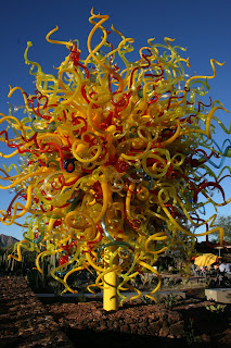
From now until May 31, 2009, there is an extraordinary exhibit of blown glass sculptures by Dale Chihuly of Seattle, Washington. This is something you have to see to believe. You may wish to spend some time viewing the videos on Chihuly's Web site to gain an appreciation of the fantastic scope of this remarkable artist.

We have been to the exhibit twice now, and will probably go back a few more times. Here are a very few pictures to give you an idea of this fabulous exhibit: